
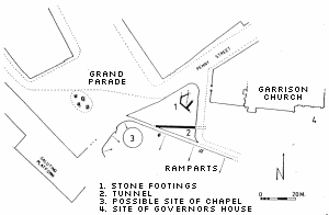
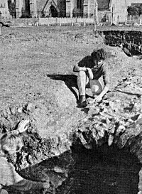
There have been relatively few archaeological digs in Old Portsmouth which is perhaps surprising given the richness and variety of human activity that has taken place there over the last millenium. One such excavation was carried out by the Portsmouth City Archaeologist Russell Fox in 1972 and it focussed on the part of Grand Parade between the Garrison Church and the Saluting Platform.
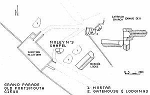
The area to be considered was determined in part by examination of a 16th Century map which showed the building complex surrounding the Domus Dei, or Garrison Church, and Bishop Moleyn's Chapel. The map is dated "before 1540", but it must also have been after 1508 when the chapel was built. It is of remarkable accuracy for the period given that the first scale map drawn in England (of Portsmouth) was dated 1545. The site was further limited by a restriction on digging in the area to the south of the Garrison church.
The excavation in the northern section of the site revealed no activity prior to the early part of the 16th century which was not expected as the area around the Domus Dei had been in use since 1220. It was concluded that the area had been stripped down for levelling purposes thereby removing evidence of any earlier activity. A mortar floor and poorly bonded wall foundations were uncovered with pottery which suggested a date of early 16th century. This structure corresponded with buildings on the map which were commonly referred to as the Gatehouse and Lodgings but it seems that they had a short life as a sturdy masonry wall ran north-south across it before turning eastwards. This appeared to be the boundary wall which enclosed the whole complex.
In the south side of the building were a series of ovens which overlapped a pit containing a quantity of copper fragments suggesting that during a later phase the building was used by a copper smith. This building appeared to have been destroyed in the last quarter of the 17th century to be partly overlain with gravel with flint cobbles set into it. Clay pipe material in the gravel indicate that it was laid around 1700. It may have represented the first parade ground seen in Portsmouth and it survived mostly intact for a hundred years, then c1800 the whole area was extensively dug into in order to erect sturdy wooden buildings. This may be evidence that an increased garrison fuelled by the onset of the Napoleonic campaigns needed some swifly erected accommodation. The whole area was subsequently resurfaced with gravel on several occasions before being turfed as we know it today.
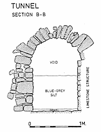
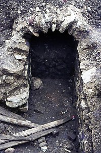
Just south of the outbuildings the archaeologists came across a solidly built tunnel of limestone construction running from west to east. The soil strata immediately above the tunnel was contemporary with the outwork described above. The tunnel itself is 1.4 metres in height with a paved floor overlain with a thin band of clean gravel. The tunnel is one third filled with clayey silt which was of a fresh water origin and had apparently been washed in through the stonework. There was an insufficient amount of the tunnel exposed to determine it's destination in either direction, though it pointed towards the Governor's house, which was contemporary, in the east and it's tempting to think it ended at the Square Tower in the west, though this is speculative.
During the dig hundreds of pottery fragments were uncovered with a wide range of origins and dates from sherds of Tudor green and Spanish Majolica to a mass of local coarseware. There were 23 different designs for clay pipes recovered, all from a forty year period from 1650.
Adapted from the report "Archaeological Excavations at Grand Parade, Old Portsmouth" by RT Fox
POSTSCRIPT
In May 2009 the Time Team carried out excavations around the Garrison Church part of which involved a radar investigation of the Parade Ground and the land immediately outside the fenced perimeter. They were able to confirm that the tunnel extended to a point just inside the fence but that the rest of it had been lost. A trench put in on the parade ground reached a depth of 1.5 metres the whole of which consisted of imported gravel. If this were applied to the whole of the parade ground then the section of the tunnel inside the current perimeter would have had to have been removed.
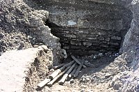
The images of the tunnel on the right are copyright Nigel Grundy who has kindly given permission for them to be published here.