The Fortifications (North)
The northern sector of the Portsmouth defences is being dealt with in sections, initially in order to allow full 360 degree panoramic views around the northern end of High Street. To accomplish this it is necessary to construct the Town Mount bastion and each of the flanking portions of ramparts. It will not be necessary at this stage to accurately build the exterior side of the defensive structures as they would not be seen from inside the town.
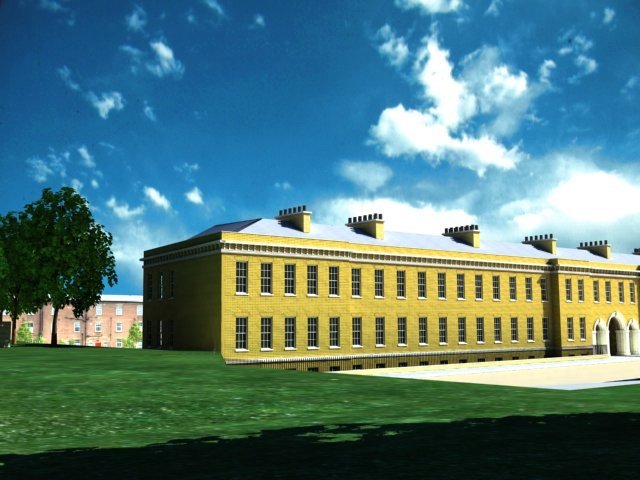
There are no known photographs showing Town Mount in the 19C, though it does appear in some drawings of the bastion prior to the modifications carried out by Colonel JP Desmaretz around 1750. Town Mount is also the site of the well known drawing from 1861 which shows the scene looking southwards to Cambridge Barracks. The lack of later images may be, in part, because it was the very first section of the fortifications to be demolished, to make way for Cambridge Road which was opened by the Duke of Cambridge on October 17th 1864 [Gates: 'Records of the Corporation'].
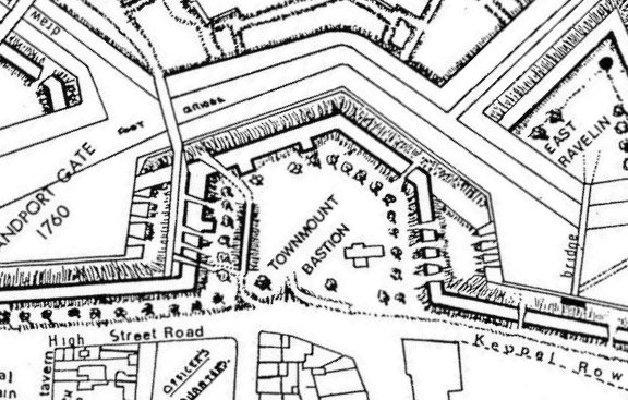
In the absence of helpful imagery we shall have to rely on the available maps, principally the OS 1:500 series from 1861. In addition, we shall be guided by the version drawn by Brian Patterson which appears in "A Military Heritage". Although Patterson's version differs in some of the detail from the OS maps he is able to use his extensive knowledge of the fortifications to indicate some of the sloping ground without which an interpretation based on the OS Maps alone would be difficult. The discepancies that do exist between the maps tend to relate to matters not directly affecting the layout of the fortifications themselves but to the surrounding vistas, such as the placement of trees. The model will be constructed using an interpretation of both.
In order to understand the structure of Town Mount it is necessary to recognise it's purpose, which differs significantly from the aggressively defensive role assigned to, say, Long Curtain or the Saluting Battery. In the first place we notice that on Town Mount there are few guns capable of firing in a northerly direction which one might have assumed would be the direction from which an enemy would approach. This, however, would be to ignore the placement of Amherst Redoubt and the two ravelins in the moat before the Town Mount whose main purpose would be to defend the town from northerly attack. It would have been only in the event that the invader had overrun the ravelins that the guns on Town Mount would have come into play and the assumption here was that the foe would launch an offensive along the line of the bridges across the moat. Had they done so they would have appreciated exactly why the Town Mount guns were placed laterally.
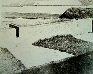
The provision of embrasures on the mount indicates that guns of a substantial size must have been deployed along the flanks, yet they were there to fire across just a few dozen yards towards very flimsy bridges. The only indication we have of the size of gun used comes in a photograph of a northerly section of Kings Bastion (see right) which overlooked the bridge before King William's Gate and presumably therefore had a similar role to the Town Mount guns. The photograph does not show the guns themselves but does give us a good idea of the width of the embrasure - possibly no larger than 12 inches. If that is the case then we can discount the use of 64pdr. guns and maybe 32pdrs. as well.
Other notable features indicated by the maps are the presence of a main magazine towards the eastern side of the bastion platform and three expense magazines against the battery walls. There appear to be two ramps leading up to the platform from street level, one presumably for pedestrians and the other for the passage of artillery. Also present are two foot bridges, both terminating in sally ports, one through the western rampart of Town Mount and the other in the rampart to the east of Town Mount, leading out to Keppel Row. It might seem odd that having thrown up such mighty works the engineers also provided weak points through the ramparts but if we look at the one such passage that has survived, that under Long Curtain leading out to the bridge towards Spur redoubt it is plain that they could be easily defended given that they were so narrow that only one person at a time could pass through.
An aspect of this section of the ramparts which has not been seen before is that of the trees. There are numerous literary references to the population of Portsmouth taking relaxing strolls along the ramparts under the great Elm Trees. Here for the first time we can get some idea of what that must have looked like. The few drawings we have of them suggest that they may have been as high as 50 feet by the time they were cut down but this could have presented problems with the roots undermining the rampart walls. For the model we have suggested that they were around 30 foot high, and in the absence of a suitable model for the elm, a generic tree has been used.
All images are copyright © Tim Backhouse. Click on the thumbnails for full size versions.