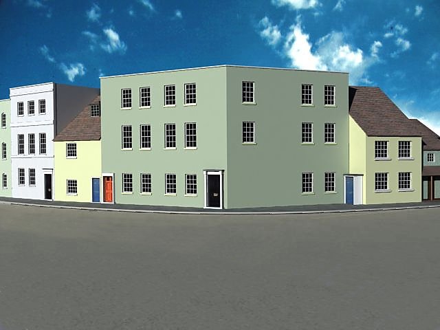
No. 145-150 High Street
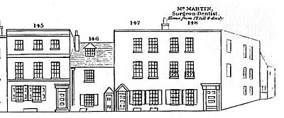
This group of buildings is at the extreme northern end of High Street. The Charpentier drawing from 1842 (see right) shows Nos. 145 to 148 which are the only ones facing the main street, but there are actually two more properties, Nos. 149 and 150, just around the corner, facing the ramparts. It is not clear whether the latter group are truly in High Street rather than High Street Road which runs along the foot of the ramparts. The directories would seem to indicate that they are in High Street.
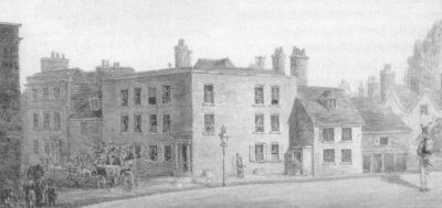
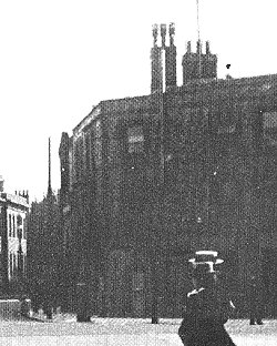
Apart from the Charpentier drawing we are fortunate in having one drawing from around the same time (below left) which shows all of the properties and a fragment of a photograph from around 1900 (below, right). The latter is particularly helpful in that it shows No. 148 to be the same building as portrayed in the earlier images and still extant at the turn of the century. Therefore it was present in 1860.
There are also a few relevant 20C photographs and although they all show that the corner of High Street did not survive the war, one of them shows the ruin of a pub on the site of Nos. 149 and 150 so plainly they had been demolished long before the war. We do not of course know exactly when this happened.
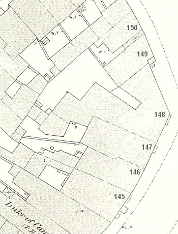
The exact layout of the buildings is not entirely clear from the drawings, so it is fortunate that the 1861 OS Map exists (see below, left) to place them all in context. Most notable from the map is the obtuse angle of the corner walls to No. 148, the extent of which is not fully evident from the images. Combining all the visual evidence allows us to suggest with some confidence that the buildings were unaltered between 1842 and 1861.
The OS Map also allows us to accurately measure the dimensions of the footprint for each building. Nos. 145-147 are 20'3", 16'0" and 17'0" wide respectively, the south-east and north facing walls of No. 148 are 18'3" and 31'5" wide respectively and Nos. 149 and 150 are 16'3" and 15'6" in width respectively. There may be some debate about the width of No. 150 as the map suggests there is another building adjacent to it which may actually be a part of it, but the 1840 drawing clearly shows a width broadly similar to it's neighbour. We have no independent evidence for the height of the buildings so they will have to be modelled in comparison to the previous block of buildings. This suggests a height of 31'0" for No. 145.
It is impossible to determine the nature of the facades as none of the drawings is clear enough though the image from around 1900 suggests the presence of brick surrounding the windows of No. 148, but this may simply be darker brick than on the rest of the face. The two drawings suggest that all surfaces were rendered.
Documentary Evidence
Slaters Directory (1852) - John Nicholas, Tailor, 147 High Street; George Hellard, Surgeon, 148 High Street; John Newlyn, Attorney, 149 High Street; Reverend Francis Mitchell, 149 High Street; George Nichols, Beer Retailer, 150 High Street;
Hunt's Directory (1852) - John Merritt Shugar, Solicitor & Insurance Agent, 145 High Street; John Nicholas, Tailor, 147 High Street; George Hellard, Surgeon, 148 High Street; Reverend Francis Mitchell, 149 High Street; Eliza Rawlinson, Beer Retailer, 150 High Street; George Shelton, Solicitor, 151 High Street;
Post Office Directory (1859) - John Lumley Aldridge, Dentist, 145 High Street;
Kelly's Directory (1859) - John Alldridge, Dentist, 145 High Street; William Savell, Beer Retailer, 150 High Street;
Simpson's Directory (1863) - None;
Harrod's (1865) Directory - John Lumley Aldridge, Dentist, 145 High Street; William Swainson, Solicitor, 148 High Street;
The 1861 Census records:-
Schedule 139 - John L. Alldridge (47, Dentist), his wife Eliza (56), sons John (17) and Douglas (10) with servant Ellen Hewitt (16);
Schedule 140 - Fanny Beesley (38 Dressmaker), her daughters Sarah (13) and Fanny (10), her son William (7), her brother Jacob Shortt (35) and visitors Patrrick and Mary O'Connor;
Schedule 141 - Martha Sheaf (60, House Proprietor);
Schedule 142 - Francis Cavanagh (38 Professor of Music), his wife Elizabeth (28) and daughters Eliza (3) and Catherine (u/1)
Schedule 143 - George ??? (40 Porter), his wife Mary (35), Daughter Eliza (10) and sons Frederick (8), George (6), William (4) and Albert (u/1)
Schedule 144 - William Swainson (57 Solicitor), his wife Charlotte (39), daughters Ann (13), Emmeline (8), Elizabeth (6) and Jane (4), sons William (3) and John (1), sister Isabella Swainson (29), neices Hannah Colley (16) and Emma Colley (15) with nurse Mary Smithers (19) and cook Kate Beacham (20);
Schedule 145 - Harriett Allen (59, House Proprietor), her daughter Frances (23) and sons Joseph (20, Engineer) and Alfred (15, Scholar)
Schedule 146 - Thomas Doling (26, Steward), his wife Ann (27) and boarder George Luxton (22)
Schedule 147 (High Street Road) - George Newell (25, Tailor), his wife Elizabeth (22) and son George (u/1), with John and Rebecca Wills
It would appear that the very top end of High Street was the abode of professional people and house owners but the evidence of who lived where is rather sketchy.
Apart from John Alldridge at No. 145 and William Swainson at No. 148 there are no names occuring in both the directories and the census which leaves us to presume that Schedules 140 - 143 refer to Nos. 146 and 147 High Street. No. 146 is rather small and probably just housed Fanny Beesley and her family whereas the larger No. 147 could have been occupied by the rest. Schedule 145 probably relates to No. 149 High Street and Schedule 146 to No. 150. As the following Schedule is annotated 'High Street Road' it may not be relevant to this section, but mistakes could have been made. It is assumed that the reference to No. 151 High Street in Hunt's Directory is an error.
Summary
The evidence above gives a good reason to model Nos 145-148 High Street as they appear in the Charpentier drawing. Nos 149 and 150 present more of a problem. Firstly we cannot be 100% sure that the two buildings with those numbers in the map (left) are correctly labelled. We have good evidence from the directories that they existed, but their omission from the Charpentier drawing is a little worrying. We can't even be sure what the name of the road on which those buildings have been placed should be called. It could be that although it is technically High Street Road a concession has been granted where they are allowed to continue with the nomenclature of High Street. A further problem is that at some point during the 1860s High Street Road was renamed St. George's Road.
Another difficulty arises with No. 150 in that the OS map shows that the footprint extends as far into the street as No. 149 whereas the drawing shows that it has a verandah which means that we have no information about the correct position for the front wall. Also we note that there is a void on the left of the building which would have allowed access to the courts behind, but it hardly seems likely that this access would require crossing the verandah. Perhaps it was simply a side entrance into the house. A degree of guesswork will be needed.
All images are copyright © Tim Backhouse. Click on the thumbnails for full size versions.